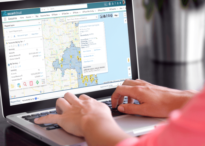
Of all the updates included in our latest Geopointe release, this might just be our favorite. Available to all Geopointe users, the new Shape Editor will fundamentally change the way you approach territory design when working with Geopointe’s shape library.
You now get a much more robust shape editing experience, allowing you to easily move sub-shapes from one shape to another and quickly see the metric impacts – before you save and exit the editor. With the editor enhancements, you have the ability to edit any shape layer while simultaneously viewing other shape layers on the map. This allows you to reference multiple territories as you compare data summaries and metrics across shapes.
The most impactful benefit you’ll see from this latest Geopointe update is an improved user experience for shape editing, resulting in huge efficiency gains. With our Shape Editor, it’s easier than ever to use Geopointe shapes as territories to aid in your territory management and planning for 2021.
Using Shape Editor to Manipulate Shapes and Territories
We redesigned the Shape Editor to be more intuitive, adding powerful new features to make your territory management easier than ever. These upgrades improve how you visualize shapes and neighboring shapes, resulting in easier manipulation without the need to constantly save and readjust.
When working in the new Shape Editor, shape selections can be handled in a couple different ways.
- The entire selection can be added to a brand new shape record that you create at that moment.
- The selected shape can be added to an existing shape on the map. (If you do this and some of the shape components are part of an existing shape, you can choose what to do with those in the existing shapes: remove them or leave them alone)
- The selected can be removed from an existing shape. (If the selected is already in multiple shapes, you can choose which to remove them from)
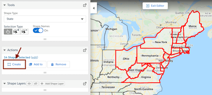
Our Shape Editor allows you to seamlessly narrow or expand your focus as you’re editing shapes that are included on the map. Only the shape being edited is defaulted to be visible on the map, but the others can be easily shown with a click. You can now see the layers and expand their info or edit info from the map. From here, you can easily add shapes to the map from the data set folders you already have in Geopointe.
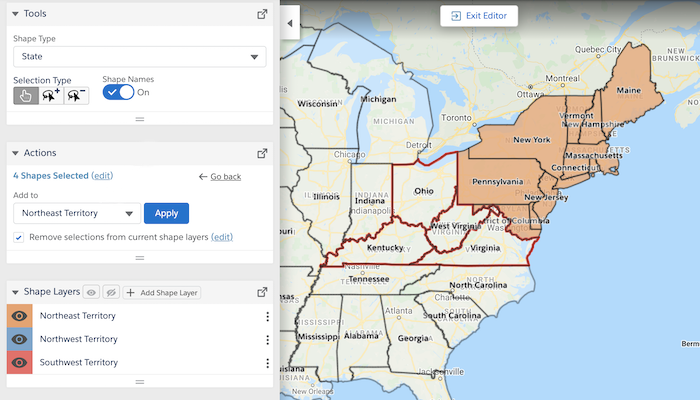
Taking advantage of the data sets you have loaded in Geopointe allows you to see the impact of any changes you make, before you make them. Rather than having to make changes, save, and then view the results of said changes, the data is updated in real time and essentially gives you a preview of the results of your adjustments.
When you’re done, you can simply exit without saving and any manipulations you made in the editor will be as if they never happened, allowing you to test out multiple “what if” scenarios and explore different outcomes – all without affecting your existing data. However, if you may make minor changes as you go along that you do want to save (but still be able to continue working without exiting), we’ve added a save button to the Editor UI so that you can essentially save your work-in-progress.
As an added bonus, Shape Editor integrates seamlessly with Assignment Plans, while also enabling a better understanding of metrics for each shape on the map.
Data Summaries
The new data summary view gives teams insight into regional performance, optimizing their decision-making. The result is an at-a-glance view of how the data lays out across the shapes and how balanced they are compared to one another. Managers can clearly visualize territory information and determine if territories should be adjusted to even out the workload for reps and account owners.
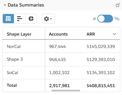
The data displayed in this summary view is driven by the Data Sets you have loaded to the map. Any numeric fields added to a Data Set can be visualized. You also have the ability to exclude a data set from the metric calculations you’re doing (currently they default to being included). For ease, a data set can even be included in the calculations without showing pins on the map.
Professionalize Your Territory Management
To sum up, the latest Geopointe release brings big changes to the way you work with our shape library and shape editor. Key aspects of the new design include:
- New! Ability to edit multiple shapes at the same time.
- New! Ability to move sub-shapes from one Geopointe shape to another, removing from one shape and adding to another with ease.
- Update! Improved ability to show or hide layers already on the map, removing the cumbersome requirement of having to open the layer manager and edit the visibility of each shape.
- Update! Visibility into summary metrics for all shapes while editing, with recalculation occurring in edit mode so users see the impact of their changes. Plus, new view of metrics that makes it easier to compare across shapes, analyzing the balance of territory assignment plans.
- New! Save all changes in one click without having to exit the editor.
Now, things are much more streamlined and smooth. The ease of working with this Shape Editor will save teams time and energy that they can devote back to doing what they do best – selling.


